
Swabi topographic map
Click on the map to display elevation.
About this map
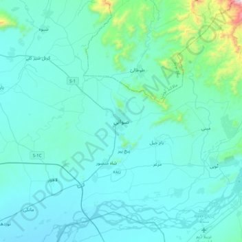
Name: Swabi topographic map, elevation, terrain.
Average elevation: 406 m
Minimum elevation: 287 m
Maximum elevation: 1,625 m
Other topographic maps
Click on a map to view its topography, its elevation and its terrain.
Indus
Pakistan > Khyber Pakhtunkhwa > Swabi District > Allāhdher
In the uppermost, highest part of the Indus River basin there are relatively few genera and species: Diptychus, Ptychobarbus, Schizopyge, Schizopygopsis and Schizothorax snowtrout, Triplophysa loaches, and the catfish Glyptosternon reticulatum. Going downstream these are soon joined by the golden mahseer Tor…
Average elevation: 281 m