Geolocate

Monte Solaro topographic map

Click on the map to display elevation.

Monte Solaro

Monte Solaro is a mountain on the island of Capri in Campania, Italy. With an elevation of 589 m, its peak is the highest point of Capri.

Wikipedia (CC-BY-SA 3.0)

About this map

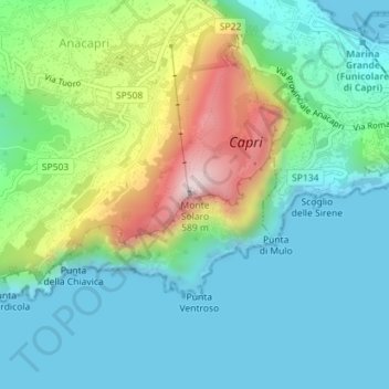
Name: Monte Solaro topographic map, elevation, terrain.

Location: Monte Solaro, Anacapri, Naples, Campania, 80071, Italy (40.54508 14.22369 40.54518 14.22379)

Average elevation: 155 m

Minimum elevation: -1 m

Maximum elevation: 570 m

Other topographic maps

Click on a map to view its topography, its elevation and its terrain.

Capri

Italy > Campania > Naples > Anacapri

Average elevation: 55 m

Capri

Italy > Campania > Naples > Anacapri

Average elevation: 55 m

Capri

Italy > Campania > Naples > Anacapri

Average elevation: 55 m

Gear up for your next adventure:

🥾Trail Hiking Shoes - Durable shoes designed for rugged trails
🔦UV Flashlight - Detect minerals or specific insects in the dark
🧭Orienteering Kit - Tools for map reading and navigation in the wild
💧Collapsible Water Bottle - Space-saving water bottle for outdoor activities
🧣Evaporative Cooling Towel - Beat the heat during intense summer climbs

As an Amazon Associate, this site earns from qualifying purchases at no extra cost to you.