Geolocate

La Florida topographic map

Click on the map to display elevation.

About this map

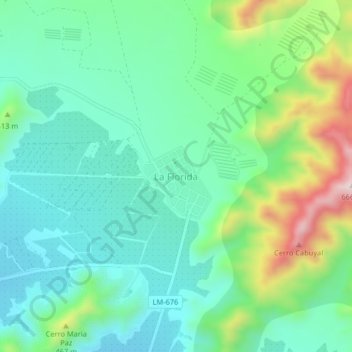
Name: La Florida topographic map, elevation, terrain.

Location: La Florida, Huaral, Lima, Perú (-11.44960 -77.20567 -11.40960 -77.16567)

Average elevation: 367 m

Minimum elevation: 251 m

Maximum elevation: 673 m

Other topographic maps

Click on a map to view its topography, its elevation and its terrain.

Lomas de Iguanil

Perú > Lima > Huaral

Average elevation: 665 m

CANAL DE RIEGO

Perú > Lima > Huaral > San Martín de Retes

Average elevation: 155 m

Gear up for your next adventure:

🧥Waterproof Pants - Keep dry during rainy hiking conditions
🛏️Camping Sleeping Mat - Comfortable mats for sleeping outdoors
🌬️Windproof Camp Stove - Efficient cooking even on exposed mountain peaks
🧢Outdoor Cap - Protective cap for sun and rain during hikes
🥾Trekking Poles - Adjustable trekking poles to reduce knee stress and improve stability

As an Amazon Associate, this site earns from qualifying purchases at no extra cost to you.