Geolocate

Padada topographic map

Click on the map to display elevation.

About this map

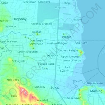
Name: Padada topographic map, elevation, terrain.

Location: Padada, Davao del Sur, Davao Region, 8007, Philippines (6.61505 125.27499 6.67164 125.41661)

Average elevation: 29 m

Minimum elevation: -6 m

Maximum elevation: 361 m

Other topographic maps

Click on a map to view its topography, its elevation and its terrain.

Darong

Philippines > Davao del Sur > Santa Cruz

Average elevation: 12 m

Binaton

Philippines > Davao del Sur > Digos

Average elevation: 421 m

Bansalan

Philippines > Davao del Sur > Bansalan

Average elevation: 157 m

Aplaya

Philippines > Davao del Sur > Hagonoy

Average elevation: 3 m

Kibanban

Philippines > Davao del Sur > Digos > Sinawilan

Average elevation: 95 m

Camlot

Philippines > Davao del Sur > Kiblawan

Average elevation: 376 m

Kinuskusan

Philippines > Davao del Sur > Bansalan

Average elevation: 346 m

Gear up for your next adventure:

Camping Groundsheet - Protect your tent from moisture and dirt
🛶Kayak Accessories - Essential gear for safe and fun kayaking adventures
🥾Waterproof Hiking Shoes - Durable shoes for wet and rugged trails
🔋Emergency Crank Radio - Weather alerts and power without needing batteries
🥾Waterproof Hiking Boots - Boots keeping your feet dry in wet conditions

As an Amazon Associate, this site earns from qualifying purchases at no extra cost to you.