Geolocate

Union topographic map

Click on the map to display elevation.

About this map

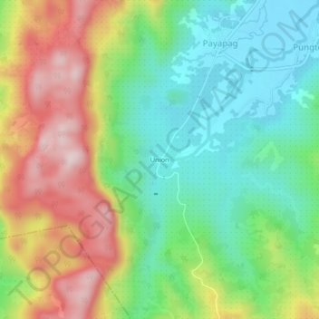
Name: Union topographic map, elevation, terrain.

Location: Union, Bacuag, Surigao del Norte, Caraga, 8406, Philippines (9.51521 125.59231 9.55521 125.63231)

Average elevation: 165 m

Minimum elevation: 13 m

Maximum elevation: 397 m

Gear up for your next adventure:

🥾Lightweight Hiking Boots - Boots for comfort and mobility on long hikes
Tent Footprint - Protect tent floor and increase durability
🧦Crew Hiking Socks - Comfortable socks for long-distance hikes
Family Camping Tent - Spacious tent suitable for family camping trips
🧣Evaporative Cooling Towel - Beat the heat during intense summer climbs

As an Amazon Associate, this site earns from qualifying purchases at no extra cost to you.