Geolocate

Chexbres topographic map

Click on the map to display elevation.

About this map

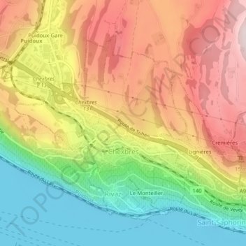
Name: Chexbres topographic map, elevation, terrain.

Location: Chexbres, District de Lavaux-Oron, Vaud, 1071, Switzerland (46.47453 6.76298 46.49360 6.79081)

Average elevation: 579 m

Minimum elevation: 367 m

Maximum elevation: 796 m

Gear up for your next adventure:

🥾Trekking Poles - Adjustable trekking poles to reduce knee stress and improve stability
🧴Outdoor Sunscreen - High SPF protection for high-altitude UV exposure
🚲Handlebar Phone Mount - View topographic-map.com live while cycling
🛌Insulated Sleeping Pad - Critical thermal barrier between you and the cold ground
🧢Hiking Hat - Sun-protective and breathable hats for long treks

As an Amazon Associate, this site earns from qualifying purchases at no extra cost to you.