Geolocate

Blang Pulo topographic map

Click on the map to display elevation.

About this map

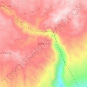
Name: Blang Pulo topographic map, elevation, terrain.

Location: Blang Pulo, Bandar, Bener Meriah, Aceh, Sumatra, Indonesia (4.72296 96.96019 4.76296 97.00019)

Average elevation: 1,143 m

Minimum elevation: 733 m

Maximum elevation: 1,307 m

Other topographic maps

Click on a map to view its topography, its elevation and its terrain.

Bukit

Indonesia > Aceh > Bener Meriah

Average elevation: 1,539 m

Bukit

Indonesia > Aceh > Bener Meriah

Average elevation: 1,539 m

Bukit

Indonesia > Aceh > Bener Meriah

Average elevation: 1,539 m

Gear up for your next adventure:

🧴Insect Repellent - Protect yourself from bugs during outdoor adventures
🧰Emergency Multi-Tool - Compact multi-tool for outdoor survival
🔦LED Flashlight - Powerful and long-lasting flashlight for camping and emergencies
🚑Survival Whistle - Signal for help across long distances in mountains
🧦Hiking Liner Socks - Thin base layer to prevent friction and blisters

As an Amazon Associate, this site earns from qualifying purchases at no extra cost to you.