
Make a donation
Gear up for your next adventure:
As an Amazon Associate, this site earns from qualifying purchases at no extra cost to you.
Preßwitz topographic map
Click on the map to display elevation.
Make a donation
Gear up for your next adventure:
As an Amazon Associate, this site earns from qualifying purchases at no extra cost to you.
Preßwitz
Ursprünglich kommt „Preßwitz“ vom sorbischen Namen „breza“ und bedeutet „Birke“. Der Ort wurde erstmals 1125 erwähnt. Im Laufe der Zeit wurde daraus der Name „Preßwitz“. Auf älteren topographischen Karten ist der Ort als Straßendorf dargestellt.
Make a donation
Gear up for your next adventure:
As an Amazon Associate, this site earns from qualifying purchases at no extra cost to you.
About this map
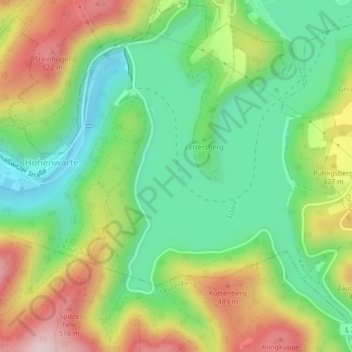
Name: Preßwitz topographic map, elevation, terrain.
Average elevation: 365 m
Minimum elevation: 241 m
Maximum elevation: 550 m
Make a donation
Gear up for your next adventure:
As an Amazon Associate, this site earns from qualifying purchases at no extra cost to you.