
Make a donation
Gear up for your next adventure:
As an Amazon Associate, this site earns from qualifying purchases at no extra cost to you.
Le Bourguet topographic map
Click on the map to display elevation.
Make a donation
Gear up for your next adventure:
As an Amazon Associate, this site earns from qualifying purchases at no extra cost to you.
About this map
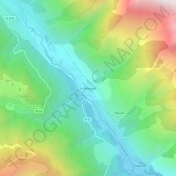
Name: Le Bourguet topographic map, elevation, terrain.
Average elevation: 1,508 m
Minimum elevation: 1,007 m
Maximum elevation: 2,538 m
Make a donation
Gear up for your next adventure:
As an Amazon Associate, this site earns from qualifying purchases at no extra cost to you.
Other topographic maps
Click on a map to view its topography, its elevation and its terrain.
Laus de Mouto
France > Provence-Alpes-Côte d'Azur > Alpes-Maritimes > Saint-Étienne-de-Tinée
Average elevation: 2,301 m
Lac Fer
France > Provence-Alpes-Côte d'Azur > Alpes-Maritimes > Saint-Étienne-de-Tinée
Le lac Fer est situé dans le massif du Mercantour, à 2 541 m d'altitude, sur la commune de Saint-Étienne-de-Tinée, dans le département des Alpes-Maritimes.
Average elevation: 2,452 m
Lacs de Vens
France > Provence-Alpes-Côte d'Azur > Alpes-Maritimes > Saint-Étienne-de-Tinée
Les lacs de Vens sont situés dans le massif du Mercantour, entre 2 286 m et 2 327 m d'altitude, sur la commune de Saint-Étienne-de-Tinée, dans le département français des Alpes-Maritimes.
Average elevation: 2,495 m