
Thank you for supporting this site ❤️
Make a donation
Make a donation
Gear up for your next adventure:
As an Amazon Associate, this site earns from qualifying purchases at no extra cost to you.
Majaelrayo topographic map
Click on the map to display elevation.
Thank you for supporting this site ❤️
Make a donation
Make a donation
Gear up for your next adventure:
As an Amazon Associate, this site earns from qualifying purchases at no extra cost to you.
Majaelrayo
La localidad se encuentra a una altitud de 1186 msnm.
Thank you for supporting this site ❤️
Make a donation
Make a donation
Gear up for your next adventure:
As an Amazon Associate, this site earns from qualifying purchases at no extra cost to you.
About this map
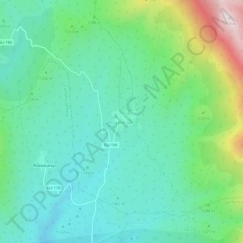
Name: Majaelrayo topographic map, elevation, terrain.
Location: Majaelrayo, Guadalajara, Castilla-La Mancha, 19223, España (41.09168 -3.32221 41.13168 -3.28221)
Average elevation: 1,253 m
Minimum elevation: 1,077 m
Maximum elevation: 1,761 m
Thank you for supporting this site ❤️
Make a donation
Make a donation
Gear up for your next adventure:
As an Amazon Associate, this site earns from qualifying purchases at no extra cost to you.