
Waldbach topographic map
Interactive map
Click on the map to display elevation.
About this map
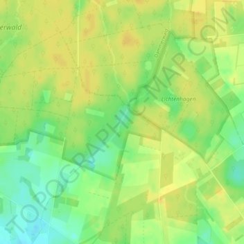
Name: Waldbach topographic map, elevation, terrain.
Average elevation: 50 m
Minimum elevation: 35 m
Maximum elevation: 58 m
Other topographic maps
Click on a map to view its topography, its elevation and its terrain.
Gahlen
Deutschland > Nordrhein-Westfalen > Kreis Wesel > Schermbeck
Gahlen, Schermbeck, Kreis Wesel, Nordrhein-Westfalen, 46514, Deutschland
Average elevation: 37 m