
Thank you for supporting this site ❤️
Make a donation
Make a donation
Gear up for your next adventure:
As an Amazon Associate, this site earns from qualifying purchases at no extra cost to you.
Barshi topographic map
Click on the map to display elevation.
Thank you for supporting this site ❤️
Make a donation
Make a donation
Gear up for your next adventure:
As an Amazon Associate, this site earns from qualifying purchases at no extra cost to you.
About this map
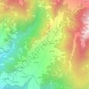
Name: Barshi topographic map, elevation, terrain.
Location: Barshi, Mestia Municipality, Samegrelo-Upper Svaneti, Georgia (43.03173 42.50615 43.07173 42.54615)
Average elevation: 1,724 m
Minimum elevation: 1,175 m
Maximum elevation: 2,389 m
Thank you for supporting this site ❤️
Make a donation
Make a donation
Gear up for your next adventure:
As an Amazon Associate, this site earns from qualifying purchases at no extra cost to you.