
Make a donation
Gear up for your next adventure:
As an Amazon Associate, this site earns from qualifying purchases at no extra cost to you.
Rohrbach-Berg topographic map
Click on the map to display elevation.
Make a donation
Gear up for your next adventure:
As an Amazon Associate, this site earns from qualifying purchases at no extra cost to you.
About this map
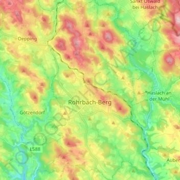
Name: Rohrbach-Berg topographic map, elevation, terrain.
Location: Rohrbach-Berg, Bezirk Rohrbach, Upper Austria, 4150, Austria (48.53480 13.95609 48.62113 14.03655)
Average elevation: 582 m
Minimum elevation: 453 m
Maximum elevation: 750 m
Make a donation
Gear up for your next adventure:
As an Amazon Associate, this site earns from qualifying purchases at no extra cost to you.
Other topographic maps
Click on a map to view its topography, its elevation and its terrain.
Sichersdorf
Austria > Upper Austria > Bezirk Rohrbach > St. Johann am Wimberg
Average elevation: 649 m
Hochficht / Smrčina
Austria > Upper Austria > Bezirk Rohrbach > Klaffer am Hochficht
Average elevation: 1,150 m
Hochficht / Smrčina
Austria > Upper Austria > Bezirk Rohrbach > Klaffer am Hochficht
Average elevation: 1,150 m
Make a donation
Gear up for your next adventure:
As an Amazon Associate, this site earns from qualifying purchases at no extra cost to you.