Geolocate

Sisiman topographic map

Click on the map to display elevation.

About this map

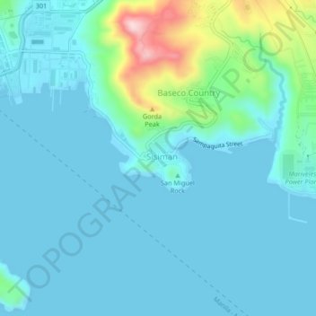
Name: Sisiman topographic map, elevation, terrain.

Location: Sisiman, Mariveles, Bataan, Central Luzon, 2106, Philippines (14.40732 120.49796 14.44732 120.53796)

Average elevation: 44 m

Minimum elevation: -2 m

Maximum elevation: 291 m

Other topographic maps

Click on a map to view its topography, its elevation and its terrain.

Laki Beach

Philippines > Bataan > Mariveles

Average elevation: 30 m

Laki Beach

Philippines > Bataan > Mariveles

Average elevation: 30 m

Gear up for your next adventure:

🪑Insulated Seat Pad - Protect your seat from cold rocks and wet logs
🧰Emergency Multi-Tool - Compact multi-tool for outdoor survival
🥾Mountain Hiking Shoes - Shoes with superior grip for mountainous terrain
🥾Approach Shoes - Shoes designed for climbing approaches and rugged trails
🧢Outdoor Cap - Protective cap for sun and rain during hikes

As an Amazon Associate, this site earns from qualifying purchases at no extra cost to you.