
Make a donation
Gear up for your next adventure:
As an Amazon Associate, this site earns from qualifying purchases at no extra cost to you.
Strafford topographic map
Click on the map to display elevation.
Make a donation
Gear up for your next adventure:
As an Amazon Associate, this site earns from qualifying purchases at no extra cost to you.
About this map
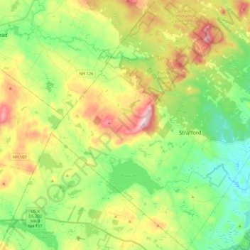
Name: Strafford topographic map, elevation, terrain.
Location: Strafford, Strafford County, New Hampshire, United States (43.20370 -71.24599 43.35532 -71.05471)
Average elevation: 202 m
Minimum elevation: 69 m
Maximum elevation: 420 m
Make a donation
Gear up for your next adventure:
As an Amazon Associate, this site earns from qualifying purchases at no extra cost to you.
Other topographic maps
Click on a map to view its topography, its elevation and its terrain.
Center Strafford
United States > New Hampshire > Strafford County > Strafford
Average elevation: 148 m
New Durham Corner
United States > New Hampshire > Strafford County > New Durham
Average elevation: 184 m
Make a donation
Gear up for your next adventure:
As an Amazon Associate, this site earns from qualifying purchases at no extra cost to you.
Bow Lake Village
United States > New Hampshire > Strafford County > Strafford
Average elevation: 174 m
Make a donation
Gear up for your next adventure:
As an Amazon Associate, this site earns from qualifying purchases at no extra cost to you.