
Make a donation
Gear up for your next adventure:
As an Amazon Associate, this site earns from qualifying purchases at no extra cost to you.
太兴山 topographic map
Click on the map to display elevation.
Make a donation
Gear up for your next adventure:
As an Amazon Associate, this site earns from qualifying purchases at no extra cost to you.
About this map
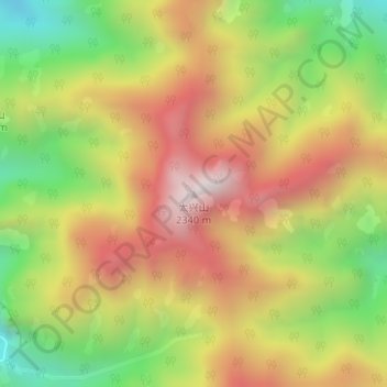
Name: 太兴山 topographic map, elevation, terrain.
Location: 太兴山, Xi'an, Shaanxi, China (33.94977 109.14333 33.94987 109.14343)
Average elevation: 1,801 m
Minimum elevation: 1,299 m
Maximum elevation: 2,281 m
Make a donation
Gear up for your next adventure:
As an Amazon Associate, this site earns from qualifying purchases at no extra cost to you.
Other topographic maps
Click on a map to view its topography, its elevation and its terrain.
Mount Taibai
The base of the mountain is composed of stone covered by yellow loess soil, while the middle elevations of the mountain are covered with hardy trees and spectacular rocky outcrops. The higher elevations of the mountain contain glacial remnants, cirque, peaks, aulacogen, and moraine, all of which have proven of…
Average elevation: 2,314 m