Geolocate

Playa del Rey topographic map

Click on the map to display elevation.

About this map

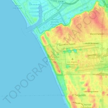
Name: Playa del Rey topographic map, elevation, terrain.

Location: Playa del Rey, Los Angeles, California, United States (33.91630 -118.51327 33.97503 -118.42221)

Average elevation: 17 m

Minimum elevation: -1 m

Maximum elevation: 60 m

Gear up for your next adventure:

🚲Bike Repair Kit - Essential tools for on-trail mechanical issues
🐕Hiking Dog Pack - Let your canine companion carry their own water and food
🧭GPS Outdoor Watch - Smart watch for navigation and fitness tracking in nature
💡Portable Camping Lamp - Rechargeable lamp for campsite lighting
🔋Emergency Crank Radio - Weather alerts and power without needing batteries

As an Amazon Associate, this site earns from qualifying purchases at no extra cost to you.