
Make a donation
Gear up for your next adventure:
As an Amazon Associate, this site earns from qualifying purchases at no extra cost to you.
Rengershausen topographic map
Click on the map to display elevation.
Make a donation
Gear up for your next adventure:
As an Amazon Associate, this site earns from qualifying purchases at no extra cost to you.
About this map
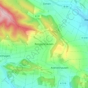
Name: Rengershausen topographic map, elevation, terrain.
Average elevation: 240 m
Minimum elevation: 163 m
Maximum elevation: 407 m
Make a donation
Gear up for your next adventure:
As an Amazon Associate, this site earns from qualifying purchases at no extra cost to you.
Other topographic maps
Click on a map to view its topography, its elevation and its terrain.
Kreiensen
Deutschland > Niedersachsen > Landkreis Northeim > Einbeck
Kreiensen liegt im Süden Niedersachsens im Leinebergland und gehört zum Harz- und Sollingvorland. Es befindet sich zwischen den Höhenzügen Helleberg im Norden, Hube im Westsüdwesten und Selter im Nordwesten. Durch den Ortskern von Kreiensen fließt die Gande, ein nordöstlicher Zufluss der Leine mit den…
Average elevation: 133 m