
Da Lat topographic map
Click on the map to display elevation.
About this map
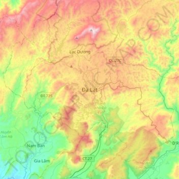
Name: Da Lat topographic map, elevation, terrain.
Average elevation: 1,360 m
Minimum elevation: 832 m
Maximum elevation: 2,093 m
Other topographic maps
Click on a map to view its topography, its elevation and its terrain.
Yersin Park
Vietnam > Lâm Đồng Province > Phường Xuân Hương - Đà Lạt > Da Lat
Average elevation: 1,482 m
Yersin Park
Vietnam > Lâm Đồng Province > Phường Xuân Hương - Đà Lạt > Da Lat
Average elevation: 1,482 m