Geolocate

Tudela topographic map

Click on the map to display elevation.

About this map

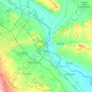
Name: Tudela topographic map, elevation, terrain.

Location: Tudela, Ribera / Erribera, Navarre, 31500, Spain (41.99260 -1.83806 42.16396 -1.48451)

Average elevation: 330 m

Minimum elevation: 235 m

Maximum elevation: 669 m

Gear up for your next adventure:

🔋Solar Power Bank - Keep your GPS and devices charged during long outdoor trips
🥾Trail Hiking Shoes - Durable shoes designed for rugged trails
🧴First Aid Kit - Essential first aid supplies for outdoor emergencies
🥾Mountaineering Boots - Supportive boots for climbing and high-altitude hiking
🐕Hiking Dog Pack - Let your canine companion carry their own water and food

As an Amazon Associate, this site earns from qualifying purchases at no extra cost to you.