
Make a donation
Gear up for your next adventure:
As an Amazon Associate, this site earns from qualifying purchases at no extra cost to you.
Kameritsch topographic map
Click on the map to display elevation.
Make a donation
Gear up for your next adventure:
As an Amazon Associate, this site earns from qualifying purchases at no extra cost to you.
About this map
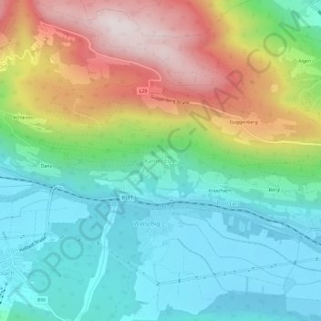
Name: Kameritsch topographic map, elevation, terrain.
Average elevation: 845 m
Minimum elevation: 578 m
Maximum elevation: 1,363 m
Make a donation
Gear up for your next adventure:
As an Amazon Associate, this site earns from qualifying purchases at no extra cost to you.
Other topographic maps
Click on a map to view its topography, its elevation and its terrain.
Pressegger See
Österreich > Kärnten > Bezirk Hermagor > Hermagor-Pressegger See > Presseggersee > Paßriach
Der hohe Wasserdurchsatz hat verhindert, dass es im See in den 1960er und 1970er Jahren zu starker Eutrophierung kam. Extreme Nährstoffbelastungen und Algenblüten blieben dem See erspart. Die Phosphorkonzentration stieg von unter 10 µg/l im Oberflächenwasser auf etwa das Doppelte an, die höchste…
Average elevation: 627 m