Geolocate

Ardross topographic map

Click on the map to display elevation.

About this map

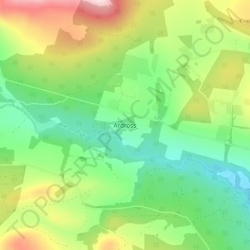
Name: Ardross topographic map, elevation, terrain.

Location: Ardross, Highland, Scotland, IV17 0YE, United Kingdom (57.71662 -4.35457 57.75662 -4.31457)

Average elevation: 223 m

Minimum elevation: 85 m

Maximum elevation: 464 m

Other topographic maps

Click on a map to view its topography, its elevation and its terrain.

Loch Ness

United Kingdom > Scotland > Highland > Dores

Average elevation: 340 m

Strathnairn

United Kingdom > Scotland > Highland > Daviot

Average elevation: 268 m

Whitebridge

United Kingdom > Scotland > Highland

Average elevation: 223 m

Glen Coe

United Kingdom > Scotland > Highland > Glencoe

Average elevation: 414 m

Gear up for your next adventure:

💡LED Camping Lantern - Illuminate your campsite with long-lasting lanterns
💧Filtered Water Bottle - Safe drinking water on the go
🛌Down Sleeping Bag - Superior warmth-to-weight ratio for cold nights
🏃Hydration Running Vest - Carry water and maps close to your body for speed
🥾Trekking Boots - Durable boots for long-distance trekking

As an Amazon Associate, this site earns from qualifying purchases at no extra cost to you.