
Make a donation
Gear up for your next adventure:
As an Amazon Associate, this site earns from qualifying purchases at no extra cost to you.
O Rial topographic map
Click on the map to display elevation.
Make a donation
Gear up for your next adventure:
As an Amazon Associate, this site earns from qualifying purchases at no extra cost to you.
About this map
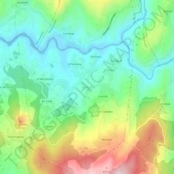
Name: O Rial topographic map, elevation, terrain.
Location: O Rial, Soutomaior, Vigo, Pontevedra, Galicien, 36691, Spanien (42.31463 -8.58979 42.35463 -8.54979)
Average elevation: 152 m
Minimum elevation: -1 m
Maximum elevation: 447 m
Make a donation
Gear up for your next adventure:
As an Amazon Associate, this site earns from qualifying purchases at no extra cost to you.
Other topographic maps
Click on a map to view its topography, its elevation and its terrain.
Redondela
Die Geografie des Bezirkes wird einerseits durch Berggipfel bis zu fast 500 Metern Höhe (im Südwesten des Gemeindebezirkes) und andererseits durch die Küstenlinie geprägt, die teils sandigen und teils felsigen Charakter aufweist. Zudem wird der Bezirk von einer topographischen Senke in Nord-Süd-Richtung…
Average elevation: 214 m
Make a donation
Gear up for your next adventure:
As an Amazon Associate, this site earns from qualifying purchases at no extra cost to you.
Make a donation
Gear up for your next adventure:
As an Amazon Associate, this site earns from qualifying purchases at no extra cost to you.