Geolocate

Myrtleford topographic map

Click on the map to display elevation.

About this map

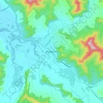
Name: Myrtleford topographic map, elevation, terrain.

Location: Myrtleford, Alpine Shire, Hume, Victoria, 3737, Australia (-36.60189 146.68616 -36.52189 146.76616)

Average elevation: 271 m

Minimum elevation: 191 m

Maximum elevation: 640 m

Other topographic maps

Click on a map to view its topography, its elevation and its terrain.

Buffalo Creek

Australia > Victoria > Myrtleford

Average elevation: 382 m

Gear up for your next adventure:

🥾Waterproof Hiking Boots - Boots keeping your feet dry in wet conditions
🧰Emergency Multi-Tool - Compact multi-tool for outdoor survival
🩹Compact First Aid Kit - Pre-packed essentials for common trail injuries
🔦LED Headlamp - Hands-free lighting for early morning starts or late finishes
🦟Insect Repellent - Keep mosquitoes and black flies away in wooded areas

As an Amazon Associate, this site earns from qualifying purchases at no extra cost to you.