Geolocate

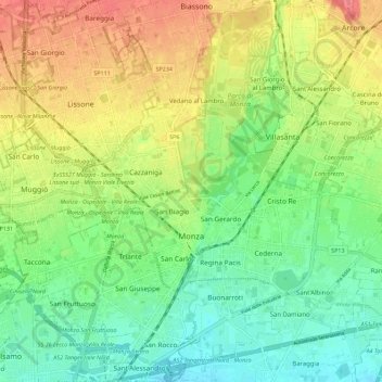
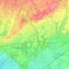
Monza topographic map

Click on the map to display elevation.

Monza

Monza is located in the high plains of Lombardy, between Brianza and Milan, at an altitude of 162 metres (531 feet) above sea level. It is 15 kilometres (9 mi) from the centre of the region's capital, although when considering the cities borders, they are separated by less than 5 km (3 miles). Monza is about 40 km (25 mi) from Lecco and Como. Monza shares its position with Milan in the same metro area, and is a big part of its new province.

Wikipedia (CC-BY-SA 3.0)

About this map

Name: Monza topographic map, elevation, terrain.

Location: Monza, Monza and Brianza, Lombardy, 20900, Italy (45.55326 9.22703 45.63220 9.32439)

Average elevation: 175 m

Minimum elevation: 145 m

Maximum elevation: 217 m

Other topographic maps

Click on a map to view its topography, its elevation and its terrain.
Cabella

Italy > Lombardy > Monza and Brianza > Camparada

Average elevation: 233 m

Oldaniga

Italy > Lombardy > Monza and Brianza > Vimercate

Average elevation: 205 m

Birago

Italy > Lombardy > Monza and Brianza > Lentate sul Seveso

Average elevation: 247 m

Oreno

Italy > Lombardy > Monza and Brianza > Vimercate

Average elevation: 195 m

Meredo

Italy > Lombardy > Monza and Brianza > Seveso

Average elevation: 219 m

Gear up for your next adventure:

🥾Durable Hiking Shoes - Long-lasting shoes for frequent hiking
🦯Trekking Poles - Reduced impact on joints for steep topographic climbs
💡Compact LED Flashlight - Powerful and portable flashlight for outdoor use
👟Leg Gaiters - Keep debris, mud, and snow out of your boots
🧭GPS Handheld Device - Reliable GPS navigation for outdoor adventures

As an Amazon Associate, this site earns from qualifying purchases at no extra cost to you.