
Make a donation
Gear up for your next adventure:
As an Amazon Associate, this site earns from qualifying purchases at no extra cost to you.
Moreton-in-Marsh topographic map
Click on the map to display elevation.
Make a donation
Gear up for your next adventure:
As an Amazon Associate, this site earns from qualifying purchases at no extra cost to you.
About this map
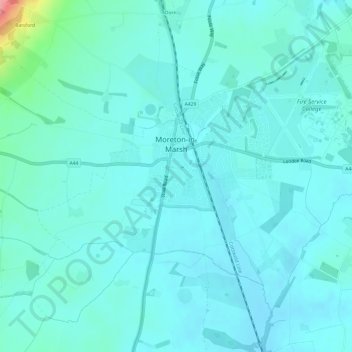
Name: Moreton-in-Marsh topographic map, elevation, terrain.
Location: Moreton-in-Marsh, Gloucestershire, England, United Kingdom (51.97303 -1.72608 52.00155 -1.66577)
Average elevation: 135 m
Minimum elevation: 120 m
Maximum elevation: 230 m
Make a donation
Gear up for your next adventure:
As an Amazon Associate, this site earns from qualifying purchases at no extra cost to you.
Other topographic maps
Click on a map to view its topography, its elevation and its terrain.
Joys Green
United Kingdom > England > Gloucestershire > Forest of Dean > Upper Lydbrook
Average elevation: 142 m
Make a donation
Gear up for your next adventure:
As an Amazon Associate, this site earns from qualifying purchases at no extra cost to you.