Geolocate

Banana topographic map

Click on the map to display elevation.

About this map

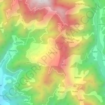
Name: Banana topographic map, elevation, terrain.

Location: Banana, Nainital, Uttarakhand, India (29.27815 79.61178 29.31815 79.65178)

Average elevation: 1,255 m

Minimum elevation: 646 m

Maximum elevation: 1,929 m

Gear up for your next adventure:

Tent Footprint - Protect tent floor and increase durability
🔪Outdoor Multitool - Versatile tool for repairs and food prep in the wild
🗺️Topographic Maps - Detailed maps to explore trails, mountains, and wilderness areas
🕶️Polarized Sunglasses - Reduces glare from snow and water at high elevations
🧥Softshell Hiking Jacket - The perfect balance of wind protection and breathability

As an Amazon Associate, this site earns from qualifying purchases at no extra cost to you.