
Make a donation
Gear up for your next adventure:
As an Amazon Associate, this site earns from qualifying purchases at no extra cost to you.
Bad Boll topographic map
Click on the map to display elevation.
Make a donation
Gear up for your next adventure:
As an Amazon Associate, this site earns from qualifying purchases at no extra cost to you.
Bad Boll
Bad Boll liegt am Nordrand der Schwäbischen Alb rund zehn Kilometer südlich von Göppingen zwischen den Gemeinden Aichelberg, Dürnau, Gruibingen und Zell u. A. Im Südosten von Bad Boll liegt der zur Gemarkung Gruibingen gehörende Kornberg (779 m ü. NN). Mit Gruibingen teilt die Gemeinde das südlich liegende ca. 122 ha große Naturschutzgebiet Teufelsloch-Kaltenwang. Südlich der Gemeinde liegt die Höhenwiese Boller Heide, ein beliebtes Ausflugsziel.
Make a donation
Gear up for your next adventure:
As an Amazon Associate, this site earns from qualifying purchases at no extra cost to you.
About this map
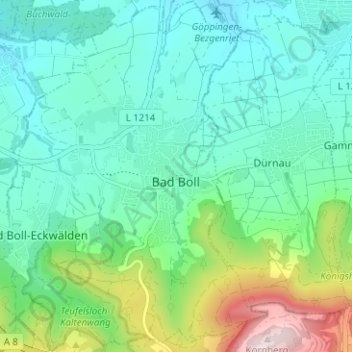
Name: Bad Boll topographic map, elevation, terrain.
Average elevation: 464 m
Minimum elevation: 364 m
Maximum elevation: 781 m
Make a donation
Gear up for your next adventure:
As an Amazon Associate, this site earns from qualifying purchases at no extra cost to you.
Other topographic maps
Click on a map to view its topography, its elevation and its terrain.
Kölleshof
Deutschland > Baden-Württemberg > Landkreis Göppingen > Drackenstein
Average elevation: 740 m
Donzdorf
Deutschland > Baden-Württemberg > Landkreis Göppingen > Donzdorf
Donzdorf liegt im Tal der Donzdorfer Lauter, einem Seitental des Filstals, auf 334 bis 749 Meter Höhe (höchste Erhebung: Messelstein), etwa 12 km von der Kreisstadt Göppingen entfernt. Das Stadtgebiet erstreckt sich vom Rehgebirge im östlichen Albvorland bis auf die Hochfläche der Schwäbischen Alb im Süden.
Average elevation: 519 m