
Make a donation
Gear up for your next adventure:
As an Amazon Associate, this site earns from qualifying purchases at no extra cost to you.
Rehburg-Loccum topographic map
Click on the map to display elevation.
Make a donation
Gear up for your next adventure:
As an Amazon Associate, this site earns from qualifying purchases at no extra cost to you.
Rehburg-Loccum
Rehburg-Loccum grenzt an das Steinhuder Meer. Das Stadtgebiet wird vom Höhenzug der Rehburger Berge durchzogen und vom Steinhuder Meerbach als Wasserablauf des Steinhuder Meeres in Ost-West-Richtung durchflossen. Der Naturpark Steinhuder Meer erstreckt sich unter anderem über das Gebiet Rehburg-Loccums.
Make a donation
Gear up for your next adventure:
As an Amazon Associate, this site earns from qualifying purchases at no extra cost to you.
About this map
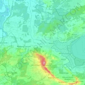
Name: Rehburg-Loccum topographic map, elevation, terrain.
Average elevation: 49 m
Minimum elevation: 23 m
Maximum elevation: 162 m
Make a donation
Gear up for your next adventure:
As an Amazon Associate, this site earns from qualifying purchases at no extra cost to you.
Other topographic maps
Click on a map to view its topography, its elevation and its terrain.
Pennigsehl
Deutschland > Niedersachsen > Landkreis Nienburg/Weser > Pennigsehl > Pennigsehl
Average elevation: 54 m
Make a donation
Gear up for your next adventure:
As an Amazon Associate, this site earns from qualifying purchases at no extra cost to you.
Make a donation
Gear up for your next adventure:
As an Amazon Associate, this site earns from qualifying purchases at no extra cost to you.
Make a donation
Gear up for your next adventure:
As an Amazon Associate, this site earns from qualifying purchases at no extra cost to you.
Haßberger Hauptgraben
Deutschland > Niedersachsen > Landkreis Nienburg/Weser > Gandesbergen
Average elevation: 22 m