
Карлово topographic map
Interactive map
Click on the map to display elevation.
About this map
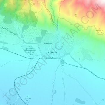
Name: Карлово topographic map, elevation, terrain.
Location: Карлово, Oblast de Plovdiv, 4300, Bulgarie (42.59582 24.76482 42.67582 24.84482)
Average elevation: 608 m
Minimum elevation: 322 m
Maximum elevation: 1,995 m
Other topographic maps
Click on a map to view its topography, its elevation and its terrain.
Радиново
Радиново, Марица, Oblast de Plovdiv, Bulgarie
Average elevation: 177 m