
Make a donation
Gear up for your next adventure:
As an Amazon Associate, this site earns from qualifying purchases at no extra cost to you.
Erbaa topographic map
Click on the map to display elevation.
Make a donation
Gear up for your next adventure:
As an Amazon Associate, this site earns from qualifying purchases at no extra cost to you.
About this map
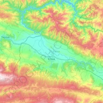
Name: Erbaa topographic map, elevation, terrain.
Location: Erbaa, Tokat, Black Sea Region, Turkey (40.49350 36.34539 40.91031 36.87274)
Average elevation: 764 m
Minimum elevation: 154 m
Maximum elevation: 1,955 m
Make a donation
Gear up for your next adventure:
As an Amazon Associate, this site earns from qualifying purchases at no extra cost to you.
Other topographic maps
Click on a map to view its topography, its elevation and its terrain.
Tokat
Turkey > Tokat > Tokat Merkez
Tokat has a hot-summer Mediterranean climate, or alternatively a continental climate (Köppen: Csa, Trewartha: Dc). Due to the relatively high altitude and inland location, winters are fairly cold with average lows below the freezing point and significant snowfall.
Average elevation: 1,137 m