
Make a donation
Gear up for your next adventure:
As an Amazon Associate, this site earns from qualifying purchases at no extra cost to you.
Laumühlen topographic map
Click on the map to display elevation.
Make a donation
Gear up for your next adventure:
As an Amazon Associate, this site earns from qualifying purchases at no extra cost to you.
About this map
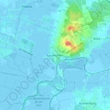
Name: Laumühlen topographic map, elevation, terrain.
Average elevation: 3 m
Minimum elevation: -4 m
Maximum elevation: 38 m
Make a donation
Gear up for your next adventure:
As an Amazon Associate, this site earns from qualifying purchases at no extra cost to you.
Other topographic maps
Click on a map to view its topography, its elevation and its terrain.
Wurster Nordseeküste
Deutschland > Niedersachsen > Landkreis Cuxhaven > Wurster Nordseeküste
Die Einheitsgemeinde wurde am 1. Januar 2015 aus den Gemeinden Cappel, Dorum, Midlum, Misselwarden, Mulsum, Nordholz, Padingbüttel und Wremen gebildet. Die Samtgemeinde Land Wursten, der alle Gemeinden außer Nordholz angehörten, wurde zum selben Termin aufgelöst. Hintergrund der Fusion war die…
Average elevation: 4 m
Bramstedt
Deutschland > Niedersachsen > Landkreis Cuxhaven > Hagen im Bremischen
Average elevation: 9 m
Make a donation
Gear up for your next adventure:
As an Amazon Associate, this site earns from qualifying purchases at no extra cost to you.