Geolocate

Clarksville topographic map

Click on the map to display elevation.

About this map

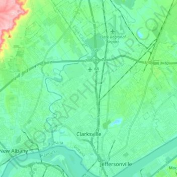
Name: Clarksville topographic map, elevation, terrain.

Location: Clarksville, Clark County, Indiana, United States (38.26805 -85.79721 38.38564 -85.74480)

Average elevation: 150 m

Minimum elevation: 111 m

Maximum elevation: 310 m

Gear up for your next adventure:

🩹Compact First Aid Kit - Pre-packed essentials for common trail injuries
🥾Hiking Shoes - Durable and comfortable shoes for trail hiking
🥾Hiking Leggings - Comfortable leggings for outdoor activities
🎒Hiking Daypack - Lightweight and durable backpacks for day trips and excursions
🧦Thermal Socks - Warm socks for winter hiking or camping

As an Amazon Associate, this site earns from qualifying purchases at no extra cost to you.