
Make a donation
Gear up for your next adventure:
As an Amazon Associate, this site earns from qualifying purchases at no extra cost to you.
Reisrach topographic map
Click on the map to display elevation.
Make a donation
Gear up for your next adventure:
As an Amazon Associate, this site earns from qualifying purchases at no extra cost to you.
About this map
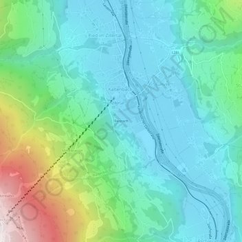
Name: Reisrach topographic map, elevation, terrain.
Location: Reisrach, Kaltenbach, Bezirk Schwaz, Tirol, 6272, Österreich (47.26552 11.85463 47.30552 11.89463)
Average elevation: 836 m
Minimum elevation: 545 m
Maximum elevation: 1,794 m
Make a donation
Gear up for your next adventure:
As an Amazon Associate, this site earns from qualifying purchases at no extra cost to you.
Other topographic maps
Click on a map to view its topography, its elevation and its terrain.
Zillertal
Österreich > Tirol > Bezirk Schwaz > Kaltenbach
Das Zillertal ist über die Zillertalstraße (B 169), die Anschluss an die Inntalautobahn bietet, erschlossen. Bei Zell am Ziller zweigt die Gerlosstraße (B 165) ab, die über den Gerlospass eine Verbindung ins Oberpinzgau darstellt. Die Zillertaler Höhenstraße ist eine kurvenreiche, mautpflichtige…
Average elevation: 1,499 m
Zillertal
Österreich > Tirol > Bezirk Schwaz > Kaltenbach
Das Zillertal zweigt etwa 40 km östlich von Innsbruck, nahe Jenbach, vom Inntal ab. Es hat seinen Namen von dem Fluss Ziller, der es von Süd nach Nord durchläuft und bei Strass im Zillertal in den Inn mündet. Im engeren Sinn reicht das Tal von Strass bis Mayrhofen. Es ist das breiteste der südlichen…
Average elevation: 1,503 m