Geolocate

Ajijic topographic map

Click on the map to display elevation.

About this map

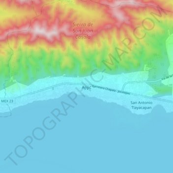
Name: Ajijic topographic map, elevation, terrain.

Location: Ajijic, Chapala, Jalisco, 45920, Mexico (20.26020 -103.30193 20.34020 -103.22193)

Average elevation: 1,738 m

Minimum elevation: 1,515 m

Maximum elevation: 2,450 m

Gear up for your next adventure:

🧤Insulated Winter Gloves - Heavy-duty protection for sub-zero Canadian adventures
🥾Mountain Hiking Boots - High-traction boots for rocky terrain
🦶Anti-Blister Balm - Prevents friction and hotspots during long ascents
👟Leg Gaiters - Keep debris, mud, and snow out of your boots
🧥Thermal Layer - Insulating layer for cold outdoor conditions

As an Amazon Associate, this site earns from qualifying purchases at no extra cost to you.