
Make a donation
Gear up for your next adventure:
As an Amazon Associate, this site earns from qualifying purchases at no extra cost to you.
New Guinsaugon topographic map
Click on the map to display elevation.
Make a donation
Gear up for your next adventure:
As an Amazon Associate, this site earns from qualifying purchases at no extra cost to you.
About this map
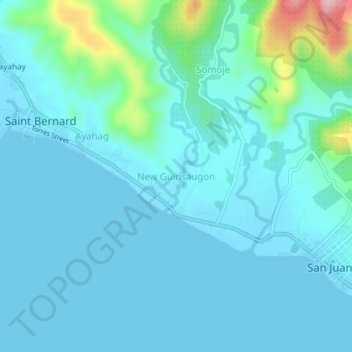
Name: New Guinsaugon topographic map, elevation, terrain.
Average elevation: 28 m
Minimum elevation: 0 m
Maximum elevation: 208 m
Make a donation
Gear up for your next adventure:
As an Amazon Associate, this site earns from qualifying purchases at no extra cost to you.
Other topographic maps
Click on a map to view its topography, its elevation and its terrain.
Limasawa
Limasawa was the second island (after Suluan) of the Philippines that the Magellan Expedition landed on. Antonio Pigafetta documented the island as "Mazaua". He described it as being inhabited with cultivated fields. In March 28, 1521 the Magellan Expedition met with two rulers, Rajah Colambu and Rahah Siaui,…
Average elevation: 1 m