
Make a donation
Gear up for your next adventure:
As an Amazon Associate, this site earns from qualifying purchases at no extra cost to you.
Copiapó topographic map
Click on the map to display elevation.
Make a donation
Gear up for your next adventure:
As an Amazon Associate, this site earns from qualifying purchases at no extra cost to you.
About this map
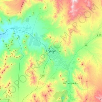
Name: Copiapó topographic map, elevation, terrain.
Average elevation: 737 m
Minimum elevation: 241 m
Maximum elevation: 1,724 m
Make a donation
Gear up for your next adventure:
As an Amazon Associate, this site earns from qualifying purchases at no extra cost to you.
Other topographic maps
Click on a map to view its topography, its elevation and its terrain.
Salar de Maricunga
Chile > Región de Atacama > Provincia de Copiapó > Copiapó
Average elevation: 3,980 m
Make a donation
Gear up for your next adventure:
As an Amazon Associate, this site earns from qualifying purchases at no extra cost to you.
Parque Nacional Desierto Florido
Chile > Región de Atacama > Provincia de Copiapó
Average elevation: 541 m
Parque Nacional Desierto Florido
Chile > Región de Atacama > Provincia de Copiapó
Average elevation: 541 m
Make a donation
Gear up for your next adventure:
As an Amazon Associate, this site earns from qualifying purchases at no extra cost to you.
Salar de Maricunga
Chile > Región de Atacama > Provincia de Copiapó > Copiapó
Average elevation: 3,980 m
Make a donation
Gear up for your next adventure:
As an Amazon Associate, this site earns from qualifying purchases at no extra cost to you.
Make a donation
Gear up for your next adventure:
As an Amazon Associate, this site earns from qualifying purchases at no extra cost to you.