Geolocate

Irixoa topographic map

Click on the map to display elevation.

About this map

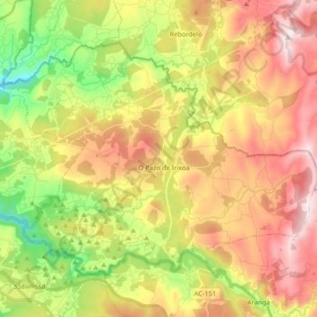
Name: Irixoa topographic map, elevation, terrain.

Location: Irixoa, Betanzos, A Coruña, Galicia, 15313, Spain (43.24423 -8.14820 43.33106 -7.98571)

Average elevation: 363 m

Minimum elevation: 30 m

Maximum elevation: 711 m

Other topographic maps

Click on a map to view its topography, its elevation and its terrain.

Quistilan

Spain > Galicia > Betanzos

Average elevation: 169 m

Burricios

Spain > Galicia > Betanzos > Oza-Cesuras

Average elevation: 267 m

Tiúlfe

Spain > Galicia > Betanzos

Average elevation: 283 m

Ansimonde

Spain > Galicia > Betanzos > Miño

Average elevation: 150 m

As Brañas

Spain > Galicia > Betanzos > O Pazo de Irixoa

Average elevation: 379 m

Cendá

Spain > Galicia > Betanzos

Average elevation: 249 m

Cesuras

Spain > Galicia > Betanzos

Average elevation: 318 m

Miño

Spain > Galicia > Betanzos

Average elevation: 41 m

Gear up for your next adventure:

👖Convertible Hiking Pants - Zip-off legs to adapt to changing weather conditions
🥽Outdoor Goggles - Protective eyewear for outdoor activities
🥾Approach Boots - Comfortable boots for hiking and climbing approaches
🚲Bike Repair Kit - Essential tools for on-trail mechanical issues
🛏️Sleeping Bag - Warm and compact sleeping bags for outdoor camping

As an Amazon Associate, this site earns from qualifying purchases at no extra cost to you.