
Make a donation
Gear up for your next adventure:
As an Amazon Associate, this site earns from qualifying purchases at no extra cost to you.
Torre de Moncorvo topographic map
Click on the map to display elevation.
Make a donation
Gear up for your next adventure:
As an Amazon Associate, this site earns from qualifying purchases at no extra cost to you.
Torre de Moncorvo
Torre de Moncorvo has a Mediterranean climate with warm to very hot, dry summers and cool, wet winters, depending on the altitude.
Make a donation
Gear up for your next adventure:
As an Amazon Associate, this site earns from qualifying purchases at no extra cost to you.
About this map
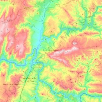
Name: Torre de Moncorvo topographic map, elevation, terrain.
Location: Torre de Moncorvo, Bragança, Portugal (41.03308 -7.22371 41.30919 -6.79818)
Average elevation: 440 m
Minimum elevation: 103 m
Maximum elevation: 908 m
Make a donation
Gear up for your next adventure:
As an Amazon Associate, this site earns from qualifying purchases at no extra cost to you.
Other topographic maps
Click on a map to view its topography, its elevation and its terrain.