Geolocate

Langschied topographic map

Click on the map to display elevation.

About this map

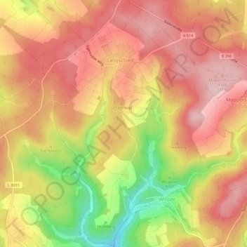
Name: Langschied topographic map, elevation, terrain.

Location: Langschied, Heidenrod, Rheingau-Taunus-Kreis, Hesse, 65321, Germany (50.14975 7.94806 50.18536 7.98392)

Average elevation: 462 m

Minimum elevation: 318 m

Maximum elevation: 547 m

Other topographic maps

Click on a map to view its topography, its elevation and its terrain.

Dickschied

Germany > Hesse > Rheingau-Taunus-Kreis

Average elevation: 358 m

Hohe Wurzel

Germany > Hesse > Rheingau-Taunus-Kreis > Taunusstein

Average elevation: 509 m

Gear up for your next adventure:

🥾All-Terrain Hiking Boots - Versatile boots for varied hiking conditions
👟Sport Hiking Sandals - Breathable footwear for water crossings and camp rest
💧Hydration Bladder - Hands-free hydration solution for long treks
🦶Hiking Shoe Insoles - Added support for high arches and long days on feet
🥾Mountain Hiking Boots - High-traction boots for rocky terrain

As an Amazon Associate, this site earns from qualifying purchases at no extra cost to you.