Geolocate

Bellbrook topographic map

Click on the map to display elevation.

About this map

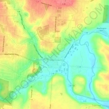
Name: Bellbrook topographic map, elevation, terrain.

Location: Bellbrook, Greene County, Ohio, 45305, United States (39.62069 -84.11178 39.65512 -84.05772)

Average elevation: 262 m

Minimum elevation: 228 m

Maximum elevation: 298 m

Other topographic maps

Click on a map to view its topography, its elevation and its terrain.

Washington Mills

United States > Ohio > Greene County

Average elevation: 263 m

Wrightview

United States > Ohio > Greene County > Fairborn

Average elevation: 269 m

Gear up for your next adventure:

🔦LED Headtorch - Bright and durable light for night activities
Family Camping Tent - Spacious tent suitable for family camping trips
🏃Hydration Running Vest - Carry water and maps close to your body for speed
🧭GPS Outdoor Watch - Smart watch for navigation and fitness tracking in nature
🧴First Aid Kit - Essential first aid supplies for outdoor emergencies

As an Amazon Associate, this site earns from qualifying purchases at no extra cost to you.