
Thank you for supporting this site ❤️
Make a donation
Make a donation
Gear up for your next adventure:
As an Amazon Associate, this site earns from qualifying purchases at no extra cost to you.
Mitchell topographic map
Click on the map to display elevation.
Thank you for supporting this site ❤️
Make a donation
Make a donation
Gear up for your next adventure:
As an Amazon Associate, this site earns from qualifying purchases at no extra cost to you.
About this map
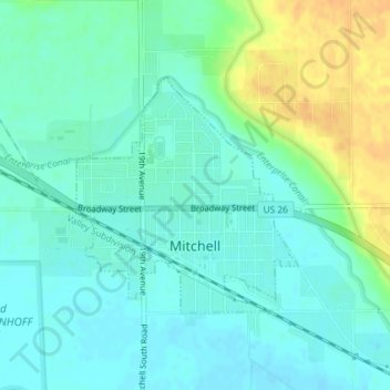
Name: Mitchell topographic map, elevation, terrain.
Location: Mitchell, Scotts Bluff County, Nebraska, United States (41.93553 -103.81972 41.95187 -103.79904)
Average elevation: 1,209 m
Minimum elevation: 1,199 m
Maximum elevation: 1,231 m
Thank you for supporting this site ❤️
Make a donation
Make a donation
Gear up for your next adventure:
As an Amazon Associate, this site earns from qualifying purchases at no extra cost to you.