
Londen topographic map
Interactive map
Click on the map to display elevation.
About this map
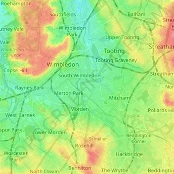
Name: Londen topographic map, elevation, terrain.
Location: Merton, Londen, Greater London, Engeland, VK (51.38015 -0.25425 51.44147 -0.12415)
Average elevation: 29 m
Minimum elevation: 4 m
Maximum elevation: 67 m
Other topographic maps
Click on a map to view its topography, its elevation and its terrain.
Walthamstow
VK > Engeland > Londen > Walthamstow
Walthamstow, Londen, Greater London, Engeland, E17 3AN, VK
Average elevation: 21 m
Regent's Canal
Regent's Canal, Londen, Greater London, Engeland, N1 0PH, VK
Average elevation: 25 m
Bow Creek Ecology Park
Bow Creek Ecology Park, Canning Town, Newham, Londen, Greater London, Engeland, VK
Average elevation: 5 m