
Utrechtse Heuvelrug topographic map
Interactive map
Click on the map to display elevation.
About this map
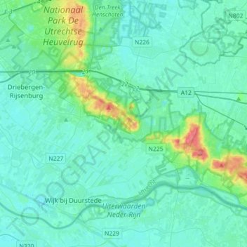
Name: Utrechtse Heuvelrug topographic map, elevation, terrain.
Location: Utrechtse Heuvelrug, Utrecht, Nederland (51.97073 5.24699 52.08657 5.52938)
Average elevation: 10 m
Minimum elevation: -3 m
Maximum elevation: 72 m
Topografische gemeentekaart van Utrechtse Heuvelrug, per december 2016