
Make a donation
Gear up for your next adventure:
As an Amazon Associate, this site earns from qualifying purchases at no extra cost to you.
Auki topographic map
Click on the map to display elevation.
Make a donation
Gear up for your next adventure:
As an Amazon Associate, this site earns from qualifying purchases at no extra cost to you.
About this map
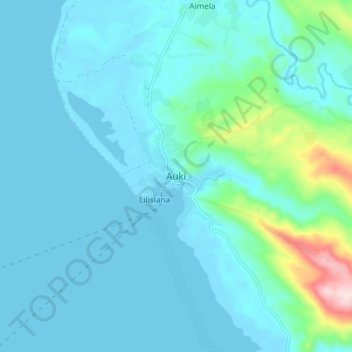
Name: Auki topographic map, elevation, terrain.
Location: Auki, Malaita, Solomon Islands (-8.81061 160.65927 -8.73061 160.73927)
Average elevation: 49 m
Minimum elevation: -1 m
Maximum elevation: 389 m
Make a donation
Gear up for your next adventure:
As an Amazon Associate, this site earns from qualifying purchases at no extra cost to you.
Other topographic maps
Click on a map to view its topography, its elevation and its terrain.
Malaita
Malaitan hydrology includes thousands of small springs, rivulets, and streams, characteristic of a young drainage pattern. At higher altitudes waterfalls are common, and in some places canyons have been cut through the limestone. Nearer the coasts, rivers are slower and deeper, and form mangrove swamps of…
Average elevation: 53 m