Geolocate

Preston topographic map

Click on the map to display elevation.

About this map

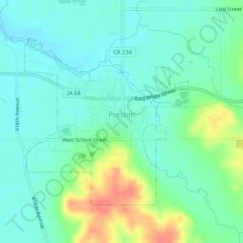
Name: Preston topographic map, elevation, terrain.

Location: Preston, Jackson County, Iowa, 52069, United States (42.04070 -90.40863 42.05932 -90.38404)

Average elevation: 207 m

Minimum elevation: 191 m

Maximum elevation: 245 m

Other topographic maps

Click on a map to view its topography, its elevation and its terrain.

Fulton

United States > Iowa > Jackson County

Average elevation: 231 m

Ozark

United States > Iowa > Jackson County

Average elevation: 266 m

Ozark

United States > Iowa > Jackson County

Average elevation: 266 m

Ozark

United States > Iowa > Jackson County

Average elevation: 266 m

Gear up for your next adventure:

🔦LED Headlamp - Hands-free lighting for early morning starts or late finishes
🛌Insulated Sleeping Pad - Critical thermal barrier between you and the cold ground
💡Compact LED Flashlight - Powerful and portable flashlight for outdoor use
🧴Waterproofing Spray - Restore the DWR coating on jackets and tents
🛶Kayak Accessories - Essential gear for safe and fun kayaking adventures

As an Amazon Associate, this site earns from qualifying purchases at no extra cost to you.