
Make a donation
Gear up for your next adventure:
As an Amazon Associate, this site earns from qualifying purchases at no extra cost to you.
Santo Domingo topographic map
Click on the map to display elevation.
Make a donation
Gear up for your next adventure:
As an Amazon Associate, this site earns from qualifying purchases at no extra cost to you.
About this map
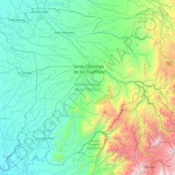
Name: Santo Domingo topographic map, elevation, terrain.
Location: Santo Domingo, Santo Domingo de los Tsáchilas, Ecuador (-0.69869 -79.54837 0.01832 -78.74609)
Average elevation: 853 m
Minimum elevation: 76 m
Maximum elevation: 3,999 m
Make a donation
Gear up for your next adventure:
As an Amazon Associate, this site earns from qualifying purchases at no extra cost to you.
Other topographic maps
Click on a map to view its topography, its elevation and its terrain.
Montañita
Ecuador > Santo Domingo de los Tsáchilas > Santo Domingo > Santo Domingo de los Tsachilas
Average elevation: 374 m
Cristo Rey
Ecuador > Santo Domingo de los Tsáchilas > La Concordia > La Villegas
Average elevation: 225 m