
Grotte topographic map
Interactive map
Click on the map to display elevation.
About this map
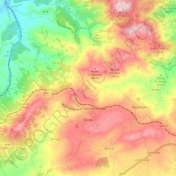
Name: Grotte topographic map, elevation, terrain.
Location: Grotte, Agrigente, Sicile, 92020, Italie (37.37526 13.64911 37.46114 13.73051)
Average elevation: 409 m
Minimum elevation: 136 m
Maximum elevation: 659 m
Other topographic maps
Click on a map to view its topography, its elevation and its terrain.
Montallegro
Montallegro, Agrigente, Sicile, 92010, Italie
Average elevation: 120 m
Île de Lampedusa
Italie > Sicile > Agrigente > Lampedusa
Île de Lampedusa, Lampedusa, Lampedusa e Linosa, Agrigente, Sicile, 92031, Italie
Average elevation: 7 m
Borgo Bonsignore
Italie > Sicile > Agrigente > Ribera
Borgo Bonsignore, Ribera, Agrigente, Sicile, 92016, Italie
Average elevation: 25 m
Riserva Naturale Orientata Foce del fiume Platani
Italie > Sicile > Agrigente > Ribera > Borgo Bonsignore
Riserva Naturale Orientata Foce del fiume Platani, Strada Provinciale 57, Borgo Bonsignore, Ribera, Agrigente, Sicile, 92016, Italie
Average elevation: 12 m