
Velden am Wörther See topographic map
Interactive map
Click on the map to display elevation.
About this map
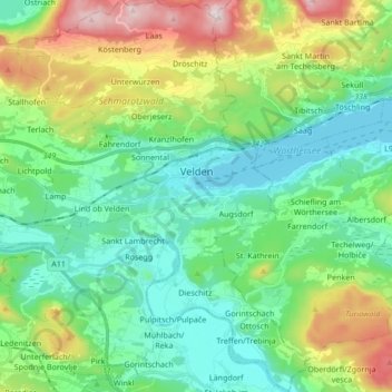
Name: Velden am Wörther See topographic map, elevation, terrain.
Location: Velden am Wörther See, Bezirk Villach-Land, Carinthia, Austria (46.54977 13.96671 46.66593 14.09389)
Average elevation: 612 m
Minimum elevation: 435 m
Maximum elevation: 1,066 m
Other topographic maps
Click on a map to view its topography, its elevation and its terrain.
Gerlitzen
Austria > Carinthia > Bezirk Villach-Land > Arriach
Gerlitzen, Arriach, Bezirk Villach-Land, Carinthia, 9543, Austria
Average elevation: 1,631 m
Semering
Austria > Carinthia > Bezirk Villach-Land > Nötsch im Gailtal > Kühweg
Semering, Kühweg, Nötsch im Gailtal, Bezirk Villach-Land, Carinthia, 9612, Austria
Average elevation: 826 m
Alberden
Austria > Carinthia > Bezirk Villach-Land > Tragail
Alberden, Tragail, Stockenboi, Bezirk Villach-Land, Carinthia, 9714, Austria
Average elevation: 696 m
Nötsch im Gailtal
Austria > Carinthia > Bezirk Villach-Land > Nötsch im Gailtal
Nötsch im Gailtal, Bezirk Villach-Land, Carinthia, Austria
Average elevation: 966 m
Faak am See
Austria > Carinthia > Bezirk Villach-Land > Finkenstein am Faaker See > Faak am See
Faak am See, Finkenstein am Faaker See, Bezirk Villach-Land, Carinthia, 9584, Austria
Average elevation: 601 m