
Section 36 topographic map
Interactive map
Click on the map to display elevation.
About this map
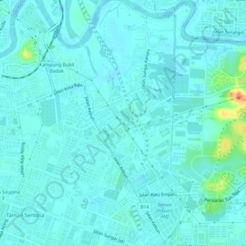
Name: Section 36 topographic map, elevation, terrain.
Location: Section 36, Shah Alam, Klang, Selangor, Malaysia (3.00368 101.47071 3.04722 101.49625)
Average elevation: 8 m
Minimum elevation: -4 m
Maximum elevation: 60 m
Other topographic maps
Click on a map to view its topography, its elevation and its terrain.
Sungai Buloh
Malaysia > Selangor > Shah Alam
Sungai Buloh, Shah Alam, Petaling, Selangor, 40160, Malaysia
Average elevation: 51 m
Section 25
Malaysia > Selangor > Shah Alam
Section 25, Shah Alam, Klang, Selangor, 42450, Malaysia
Average elevation: 6 m
Broken Heart Lake trail
Malaysia > Selangor > Shah Alam
Broken Heart Lake trail, Section U10, Shah Alam, Petaling, Selangor, 40710, Malaysia
Average elevation: 65 m
Kelab Darul Ehsan
Malaysia > Selangor > Shah Alam
Kelab Darul Ehsan, D'Kayangan, Section 11, Shah Alam, Selangor, Malaysia
Average elevation: 25 m
Section 13
Malaysia > Selangor > Shah Alam > Section 13
Section 13, Shah Alam, Selangor, 40675, Malaysia
Average elevation: 22 m